You have 0 items in your cart

Section 5. Other Airspace Areas
-
Airport Advisory/Information Services
-
There are two advisory type services available at selected airports.
-
Local Airport Advisory (LAA) service is available only in Alaska and is operated within 10 statute miles of an airport where a control tower is not operating but where a FSS is located on the airport. At such locations, the FSS provides a complete local airport advisory service to arriving and departing aircraft. During periods of fast changing weather the FSS will automatically provide Final Guard as part of the service from the time the aircraft reports “on-final” or “taking-the-active-runway” until the aircraft reports “on-the-ground” or “airborne.”
NOTE-
Current policy, when requesting remote ATC services, requires that a pilot monitor the automated weather broadcast at the landing airport prior to requesting ATC services. The FSS automatically provides Final Guard, when appropriate, during LAA/Remote Airport Advisory (RAA) operations. Final Guard is a value added wind/altimeter monitoring service, which provides an automatic wind and altimeter check during active weather situations when the pilot reports on-final or taking the active runway. During the landing or take-off operation when the winds or altimeter are actively changing the FSS will blind broadcast significant changes when the specialist believes the change might affect the operation. Pilots should acknowledge the first wind/altimeter check but due to cockpit activity no acknowledgement is expected for the blind broadcasts. It is prudent for a pilot to report on-the-ground or airborne to end the service.
-
Remote Airport Information Service (RAIS) is provided in support of short term special events like small to medium fly-ins. The service is advertised by NOTAM D only. The FSS will not have access to a continuous readout of the current winds and altimeter; therefore, RAIS does not include weather and/or Final Guard service. However, known traffic, special event instructions, and all other services are provided.
NOTE-
The airport authority and/or manager should request RAIS support on official letterhead directly with the manager of the FSS that will provide the service at least 30 days in advance. Approval authority rests with the FSS manager and is based on workload and resource availability.
REFERENCE-
AIM, Para 4-1-9, Traffic Advisory Practices at Airports Without Operating Control Towers.
-
Local Airport Advisory (LAA) service is available only in Alaska and is operated within 10 statute miles of an airport where a control tower is not operating but where a FSS is located on the airport. At such locations, the FSS provides a complete local airport advisory service to arriving and departing aircraft. During periods of fast changing weather the FSS will automatically provide Final Guard as part of the service from the time the aircraft reports “on-final” or “taking-the-active-runway” until the aircraft reports “on-the-ground” or “airborne.”
- It is not mandatory that pilots participate in the Airport Advisory programs. Participation enhances safety for everyone operating around busy GA airports; therefore, everyone is encouraged to participate and provide feedback that will help improve the program.
-
There are two advisory type services available at selected airports.
-
Military Training Routes
- National security depends largely on the deterrent effect of our airborne military forces. To be proficient, the military services must train in a wide range of airborne tactics. One phase of this training involves “low level” combat tactics. The required maneuvers and high speeds are such that they may occasionally make the see‐and‐avoid aspect of VFR flight more difficult without increased vigilance in areas containing such operations. In an effort to ensure the greatest practical level of safety for all flight operations, the Military Training Route (MTR) program was conceived.
- The MTR program is a joint venture by the FAA and the Department of Defense (DoD). MTRs are mutually developed for use by the military for the purpose of conducting low‐altitude, high‐speed training. The routes above 1,500 feet AGL are developed to be flown, to the maximum extent possible, under IFR. The routes at 1,500 feet AGL and below are generally developed to be flown under VFR.
-
Generally, MTRs are established below 10,000 feet MSL for operations at speeds in excess of 250 knots. However, route segments may be defined at higher altitudes for purposes of route continuity. For example, route segments may be defined for descent, climbout, and mountainous terrain. There are IFR and VFR routes as follows:
- IFR Military Training Routes-(IR). Operations on these routes are conducted in accordance with IFR regardless of weather conditions.
- VFR Military Training Routes-(VR). Operations on these routes are conducted in accordance with VFR except flight visibility must be 5 miles or more; and flights must not be conducted below a ceiling of less than 3,000 feet AGL.
-
Military training routes will be identified and charted as follows:
-
Route identification.
- MTRs with no segment above 1,500 feet AGL must be identified by four number characters; e.g., IR1206, VR1207.
- MTRs that include one or more segments above 1,500 feet AGL must be identified by three number characters; e.g., IR206, VR207.
- Alternate IR/VR routes or route segments are identified by using the basic/principal route designation followed by a letter suffix, e.g., IR008A, VR1007B, etc.
-
Route charting.
- IFR Enroute Low Altitude Chart. This chart will depict all IR routes and all VR routes that accommodate operations above 1,500 feet AGL.
- VFR Sectional Aeronautical Charts. These charts will depict military training activities such as IR and VR information. Special Military Activity Routes (SMARs) may also be charted on the VFR Sectional Chart, showing the extent of the airspace allocated to the associated IFR Military Training Routes within which the Department of Defense conducts periodic operations involving Unmanned Aircraft Systems. These aircraft may be accompanied by military or other aircraft that provide the pilots of the Unmanned Aircraft Systems visual observation information about other aircraft operations near them. Further information on SMAR charting can be found on the border of the printed VFR Sectional Chart and in the FAA Aeronautical Chart Users' Guide available online at: https://www.faa.gov/air_traffic/flight_info/aeronav/digital_products/aero_guide/.
-
Area Planning (AP/1B) Chart (DoD Flight Information Publication-FLIP). This chart is published by the National Geospatial-Intelligence Agency (NGA) primarily for military users and contains detailed information on both IR and VR routes.
REFERENCE-
AIM, Para 9-1-6, Subpara a, National Geospatial-Intelligence Agency (NGA) Products.
-
Route identification.
-
DoD FLIP- Department of Defense Flight Information Publications describe IR/VR routes through charts and narratives, and the FAA provides information regarding these routes to all users via IFR and VFR charts.
NOTE-
DoD users that require copies of FLIP should contact: Defense Logistics Agency for Aviation
MTR information from the FLIP is available for pilot briefings through Flight Service. (See subparagraph f below.)
Mapping Customer Operations (DLA AVN/QAM)
8000 Jefferson Davis Highway
Richmond, VA 23297-5339
Toll free phone: 1-800-826-0342
Commercial: 804-279-6500 -
Availability of MTR information.
- Pilots may obtain preflight MTR information through Flight Service (see paragraph 5-1-1, Preflight Preparation).
-
MTR routes are depicted on IFR En Route Low Altitude Charts and VFR Sectional Charts, which are available for free download on the FAA website at
https://www.faa.gov/air_traffic/flight_info/aeronav/digital_products/.
- Nonparticipating aircraft are not prohibited from flying within an MTR or SMAR; however, extreme vigilance should be exercised when conducting flight through or near these routes. Pilots, while inflight, should contact the FSS within 100 NM of a particular MTR to obtain current information or route usage in their vicinity. Information available includes times of scheduled activity, altitudes in use on each route segment, and actual route width. Route width varies for each MTR and can extend several miles on either side of the charted MTR centerline. Route width information for IFR Military Training Route (IR) and VFR Military Training Route (VR) MTRs is also available in the FLIP AP/1B along with additional MTR (slow routes/air refueling routes) information. When requesting MTR information, pilots should give the FSS the MTR designation of interest, their position, route of flight, and destination in order to reduce frequency congestion and permit the FSS specialist to identify the MTR or SMAR that could be a factor.
-
Temporary Flight Restrictions
- General. This paragraph describes the types of conditions under which the FAA may impose temporary flight restrictions. It also explains which FAA elements have been delegated authority to issue a temporary flight restrictions NOTAM and lists the types of responsible agencies/offices from which the FAA will accept requests to establish temporary flight restrictions. The 14 CFR is explicit as to what operations are prohibited, restricted, or allowed in a temporary flight restrictions area. Pilots are responsible to comply with 14 CFR sections 91.137, 91.138, 91.141 and 91.143 when conducting flight in an area where a temporary flight restrictions area is in effect, and should check appropriate NOTAMs during flight planning.
-
The purpose for establishing a temporary flight restrictions area is to:
- Protect persons and property in the air or on the surface from an existing or imminent hazard associated with an incident on the surface when the presence of low flying aircraft would magnify, alter, spread, or compound that hazard (14 CFR section 91.137(a)(1));
- Provide a safe environment for the operation of disaster relief aircraft (14 CFR section 91.137(a)(2)); or
- Prevent an unsafe congestion of sightseeing aircraft above an incident or event which may generate a high degree of public interest (14 CFR section 91.137(a)(3)).
- Protect declared national disasters for humanitarian reasons in the State of Hawaii (14 CFR section 91.138).
- Protect the President, Vice President, or other public figures (14 CFR section 91.141).
- Provide a safe environment for space agency operations (14 CFR section 91.143).
- Except for hijacking situations, when the provisions of 14 CFR section 91.137(a)(1) or (a)(2) are necessary, a temporary flight restrictions area will only be established by or through the area manager at the Air Route Traffic Control Center (ARTCC) having jurisdiction over the area concerned. A temporary flight restrictions NOTAM involving the conditions of 14 CFR section 91.137(a)(3) will be issued at the direction of the service area office director having oversight of the airspace concerned. When hijacking situations are involved, a temporary flight restrictions area will be implemented through the TSA Aviation Command Center. The appropriate FAA air traffic element, upon receipt of such a request, will establish a temporary flight restrictions area under 14 CFR section 91.137(a)(1).
- The FAA accepts recommendations for the establishment of a temporary flight restrictions area under 14 CFR section 91.137(a)(1) from military major command headquarters, regional directors of the Office of Emergency Planning, Civil Defense State Directors, State Governors, or other similar authority. For the situations involving 14 CFR section 91.137(a)(2), the FAA accepts recommendations from military commanders serving as regional, subregional, or Search and Rescue (SAR) coordinators; by military commanders directing or coordinating air operations associated with disaster relief; or by civil authorities directing or coordinating organized relief air operations (includes representatives of the Office of Emergency Planning, U.S. Forest Service, and State aeronautical agencies). Appropriate authorities for a temporary flight restrictions establishment under 14 CFR section 91.137(a)(3) are any of those listed above or by State, county, or city government entities.
- The type of restrictions issued will be kept to a minimum by the FAA consistent with achievement of the necessary objective. Situations which warrant the extreme restrictions of 14 CFR section 91.137(a)(1) include, but are not limited to: toxic gas leaks or spills, flammable agents, or fumes which if fanned by rotor or propeller wash could endanger persons or property on the surface, or if entered by an aircraft could endanger persons or property in the air; imminent volcano eruptions which could endanger airborne aircraft and occupants; nuclear accident or incident; and hijackings. Situations which warrant the restrictions associated with 14 CFR section 91.137(a)(2) include: forest fires which are being fought by releasing fire retardants from aircraft; and aircraft relief activities following a disaster (earthquake, tidal wave, flood, etc.). 14 CFR section 91.137(a)(3) restrictions are established for events and incidents that would attract an unsafe congestion of sightseeing aircraft.
- The amount of airspace needed to protect persons and property or provide a safe environment for rescue/relief aircraft operations is normally limited to within 2,000 feet above the surface and within a 3-nautical-mile radius. Incidents occurring within Class B, Class C, or Class D airspace will normally be handled through existing procedures and should not require the issuance of a temporary flight restrictions NOTAM. Temporary flight restrictions affecting airspace outside of the U.S. and its territories and possessions are issued with verbiage excluding that airspace outside of the 12-mile coastal limits.
- The FSS nearest the incident site is normally the “coordination facility.” When FAA communications assistance is required, the designated FSS will function as the primary communications facility for coordination between emergency control authorities and affected aircraft. The ARTCC may act as liaison for the emergency control authorities if adequate communications cannot be established between the designated FSS and the relief organization. For example, the coordination facility may relay authorizations from the on‐scene emergency response official in cases where news media aircraft operations are approved at the altitudes used by relief aircraft.
- ATC may authorize operations in a temporary flight restrictions area under its own authority only when flight restrictions are established under 14 CFR section 91.137(a)(2) and (a)(3). The appropriate ARTCC/airport traffic control tower manager will, however, ensure that such authorized flights do not hamper activities or interfere with the event for which restrictions were implemented. However, ATC will not authorize local IFR flights into the temporary flight restrictions area.
-
To preclude misunderstanding, the implementing NOTAM will contain specific and formatted information. The facility establishing a temporary flight restrictions area will format a NOTAM beginning with the phrase “FLIGHT RESTRICTIONS” followed by: the location of the temporary flight restrictions area; the effective period; the area defined in statute miles; the altitudes affected; the FAA coordination facility and commercial telephone number; the reason for the temporary flight restrictions; the agency directing any relief activities and its commercial telephone number; and other information considered appropriate by the issuing authority.
EXAMPLE-
- 14 CFR section 91.137(a)(1):
The following NOTAM prohibits all aircraft operations except those specified in the NOTAM.
Flight restrictions Matthews, Virginia, effective immediately until 9610211200. Pursuant to 14 CFR section 91.137(a)(1) temporary flight restrictions are in effect. Rescue operations in progress. Only relief aircraft operations under the direction of the Department of Defense are authorized in the airspace at and below 5,000 feet MSL within a 2-nautical-mile radius of Laser AFB, Matthews, Virginia. Commander, Laser AFB, in charge (897) 946-5543 (122.4). Steenson FSS (792) 555-6141 (123.1) is the FAA coordination facility. - 14 CFR section 91.137(a)(2):
The following NOTAM permits flight operations in accordance with 14 CFR section 91.137(a)(2). The on‐site emergency response official to authorize media aircraft operations below the altitudes used by the relief aircraft. Flight restrictions 25 miles east of Bransome, Idaho, effective immediately until 9601202359 UTC. Pursuant to 14 CFR section 91.137(a)(2) temporary flight restrictions are in effect within a 4-nautical-mile radius of the intersection of county roads 564 and 315 at and below 3,500 feet MSL to provide a safe environment for fire fighting aircraft operations. Davis County sheriff's department (792) 555-8122 (122.9) is in charge of on‐scene emergency response activities. Glivings FSS (792) 555-1618 (122.2) is the FAA coordination facility. - 14 CFR section 91.137(a)(3):
The following NOTAM prohibits sightseeing aircraft operations.
Flight restrictions Brown, Tennessee, due to olympic activity. Effective 9606181100 UTC until 9607190200 UTC. Pursuant to 14 CFR section 91.137(a)(3) temporary flight restrictions are in effect within a 3-nautical-mile radius of N355783/W835242 and Volunteer VORTAC 019 degree radial 3.7 DME fix at and below 2,500 feet MSL. Norton FSS (423) 555-6742 (126.6) is the FAA coordination facility. - 14 CFR section 91.138:
The following NOTAM prohibits all aircraft except those operating under the authorization of the official in charge of associated emergency or disaster relief response activities, aircraft carrying law enforcement officials, aircraft carrying personnel involved in an emergency or legitimate scientific purposes, carrying properly accredited news media, and aircraft operating in accordance with an ATC clearance or instruction.
Flight restrictions Kapalua, Hawaii, effective 9605101200 UTC until 9605151500 UTC. Pursuant to 14 CFR section 91.138 temporary flight restrictions are in effect within a 3-nautical-mile radius of N205778/W1564038 and Maui/OGG/VORTAC 275 degree radial at 14.1 nautical miles. John Doe 808-757-4469 or 122.4 is in charge of the operation. Honolulu/HNL 808-757-4470 (123.6) FSS is the FAA coordination facility. - 14 CFR section 91.141:
The following NOTAM prohibits all aircraft.
Flight restrictions Stillwater, Oklahoma, June 21, 1996. Pursuant to 14 CFR section 91.141 aircraft flight operations are prohibited within a 3-nautical-mile radius, below 2000 feet AGL of N360962/W970515 and the Stillwater/SWO/VOR/DME 176 degree radial 3.8-nautical-mile fix from 1400 local time to 1700 local time June 21, 1996, unless otherwise authorized by ATC. - 14 CFR section 91.143:
The following NOTAM prohibits any aircraft of U.S. registry, or pilot any aircraft under the authority of an airman certificate issued by the FAA.
Kennedy space center space operations area effective immediately until 9610152100 UTC. Pursuant to 14 CFR section 91.143, flight operations conducted by FAA certificated pilots or conducted in aircraft of U.S. registry are prohibited at any altitude from surface to unlimited, within the following area 30-nautical-mile radius of the Melbourne/MLB/VORTAC 010 degree radial 21-nautical-mile fix. St. Petersburg, Florida/PIE/FSS 813-545-1645 (122.2) is the FAA coordination facility and should be contacted for the current status of any airspace associated with the space shuttle operations. This airspace encompasses R2933, R2932, R2931, R2934, R2935, W497A and W158A. Additional warning and restricted areas will be active in conjunction with the operations. Pilots must consult all NOTAMs regarding this operation.
- 14 CFR section 91.137(a)(1):
-
Parachute Jump Aircraft Operations
- Procedures relating to parachute jump areas are contained in 14 CFR part 105. Tabulations of parachute jump areas in the U.S. are contained in the Chart Supplement.
- Pilots of aircraft engaged in parachute jump operations are reminded that all reported altitudes must be with reference to mean sea level, or flight level, as appropriate, to enable ATC to provide meaningful traffic information.
- Parachute operations in the vicinity of an airport without an operating control tower - there is no substitute for alertness while in the vicinity of an airport. It is essential that pilots conducting parachute operations be alert, look for other traffic, and exchange traffic information as recommended in paragraph 4-1-9, Traffic Advisory Practices at Airports Without Operating Control Towers. In addition, pilots should avoid releasing parachutes while in an airport traffic pattern when there are other aircraft in that pattern. Pilots should make appropriate broadcasts on the designated Common Traffic Advisory Frequency (CTAF), and monitor that CTAF until all parachute activity has terminated or the aircraft has left the area. Prior to commencing a jump operation, the pilot should broadcast the aircraft's altitude and position in relation to the airport, the approximate relative time when the jump will commence and terminate, and listen to the position reports of other aircraft in the area.
-
Published VFR Routes
Published VFR routes for transitioning around, under and through complex airspace such as Class B airspace were developed through a number of FAA and industry initiatives. All of the following terms, i.e., “VFR Flyway” “VFR Corridor” and “VFR Transition Route” have been used when referring to the same or different types of routes or airspace. The following paragraphs identify and clarify the functionality of each type of route and specify where and when an ATC clearance is required.
-
VFR Flyways.
-
A VFR Flyway is defined as a general flight path not defined as a specific course, for use by pilots in planning flights into, out of, through or near complex terminal airspace to avoid Class B airspace. An ATC clearance is NOT required to fly these routes.
FIG 3-5-1
VFR Flyway Planning Chart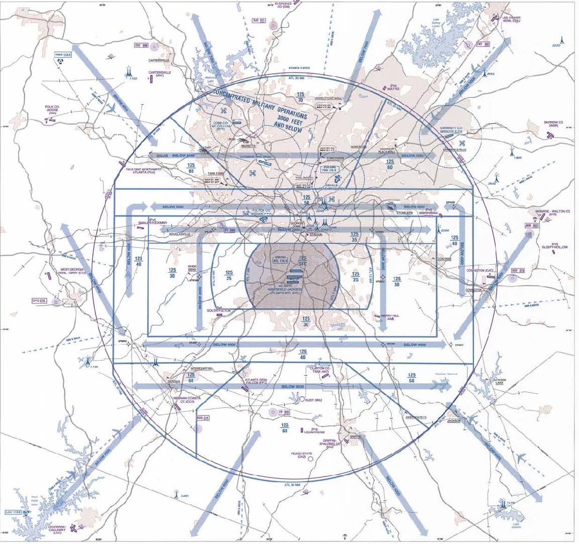
- VFR Flyways are depicted on the reverse side of some VFR Terminal Area Charts (TACs). (See FIG 3-5-1.) These charts identify VFR Flyways designed to help VFR pilots avoid major controlled traffic flows. They may further depict multiple VFR routings throughout the area which may be used as an alternative to flight within Class B airspace. The ground references provide a guide for improved visual navigation. These routes are not intended to discourage requests for VFR operations within Class B airspace but are designed solely to assist pilots in planning for flights under and around busy Class B airspace without entering Class B airspace.
- It is very important to remember that these suggested routes are not sterile of other traffic. The entire Class B airspace, and the airspace underneath it, may be heavily congested with many different types of aircraft. Pilot adherence to VFR rules must be exercised at all times. Communications must be established and maintained between your aircraft and any control tower while transiting Class C or Class D surface areas of airports under Class B airspace.
-
A VFR Flyway is defined as a general flight path not defined as a specific course, for use by pilots in planning flights into, out of, through or near complex terminal airspace to avoid Class B airspace. An ATC clearance is NOT required to fly these routes.
-
VFR Corridors.
- The design of a few of the first Class B airspace areas provided a corridor for the passage of uncontrolled traffic. A VFR corridor is defined as airspace through Class B airspace, with defined vertical and lateral boundaries, in which aircraft may operate without an ATC clearance or communication with air traffic control.
-
These corridors are, in effect, a “hole” through Class B airspace. (See FIG 3-5-2.) A classic example would be the corridor through the Los Angeles Class B airspace, which has been subsequently changed to Special Flight Rules airspace (SFR). A corridor is surrounded on all sides by Class B airspace and does not extend down to the surface like a VFR Flyway. Because of their finite lateral and vertical limits, and the volume of VFR traffic using a corridor, extreme caution and vigilance must be exercised.
FIG 3-5-2
Class B Airspace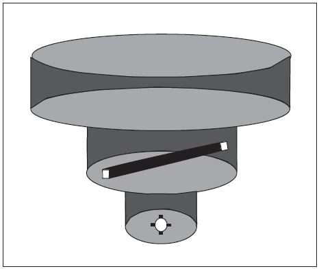
- Because of the heavy traffic volume and the procedures necessary to efficiently manage the flow of traffic, it has not been possible to incorporate VFR corridors in the development or modifications of Class B airspace in recent years.
-
VFR Transition Routes.
- To accommodate VFR traffic through terminal airspace, VFR Transition Routes were developed. A VFR Transition Route is defined as a specific flight course depicted and described on a TAC and/or VFR Flyway Planning Chart. Communication with ATC where the route transitions Class B, Class C, and/or Class D airspace is required. In addition to communication requirements, a clearance is required to operate in Class B airspace. VFR Transition Routes may include published altitudes or ATC‐assigned altitudes. Per 14 CFR section 91.123, pilot compliance is expected for all route and altitude restrictions as published or assigned by ATC. VFR Transition Route and altitude assignments do not relieve pilots from their duty to comply with 14 CFR section 91.119. Pilots are expected to request an alternate clearance if necessary for compliance.
- These routes, as depicted in FIG 3-5-3, are designed to show the pilot where to position the aircraft where an ATC assignment or clearance for the route can normally be expected with minimal or no delay.Until ATC authorization is received, pilots must remain clear of Class B airspace.On initial contact, pilots should advise ATC of their position, altitude, route name desired, and direction of flight.
-
For secondary airports underlying or in close proximity to Class B or Class C airspace, VFR Transition Routes may be developed and depicted for arrivals/departures. These arrivals/departures may be requested from or assigned by ATC.
FIG 3-5-3
VFR Transition Route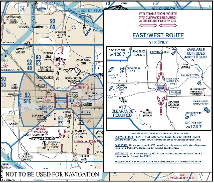
-
Helicopter Route Chart.
- Helicopter Routes are depicted on a specialized VFR chart established for select high traffic density areas to enhance helicopter access and ease of operation. The Helicopter Route Chart depicts prominent geographical features, roads and obstructions. A Helicopter Route is a specific VFR flight course and is depicted on the Helicopter Route Chart. These routes contain specific altitudes and instructions for navigating over visual reference points as published, or as instructed by ATC.
-
Helicopter Route Charts, as depicted in FIG 3-5-4, incorporate expanded ground reference and unique symbology to improve visual navigation. The charts contain additional information such as frequencies to self-announce on and other route information. On initial contact, pilots should advise ATC of their position, altitude, and route name desired. Helicopter Routes may include published altitudes or ATC‐assigned altitudes. Per 14 CFR section 91.123, pilot compliance is expected for all route and altitude restrictions as published or assigned by ATC. Helicopter Route and altitude assignments do not relieve pilots from their duty to comply with 14 CFR section 91.119 and 132.203(b). Pilots are expected to request an alternate clearance if necessary for compliance.
FIG 3-5-4
Helicopter Route Chart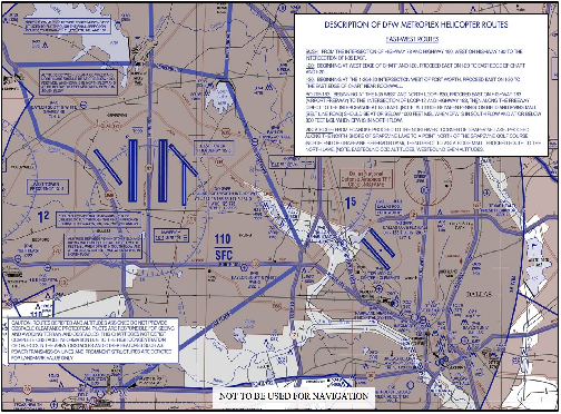
-
VFR Flyways.
-
Terminal Radar Service Area (TRSA)
- Background. TRSAs were originally established as part of the Terminal Radar Program at selected airports. TRSAs were never controlled airspace from a regulatory standpoint because the establishment of TRSAs was never subject to the rulemaking process; consequently, TRSAs are not contained in 14 CFR part 71 nor are there any TRSA operating rules in 14 CFR part 91. Part of the Airport Radar Service Area (ARSA) program was to eventually replace all TRSAs. However, the ARSA requirements became relatively stringent and it was subsequently decided that TRSAs would have to meet ARSA criteria before they would be converted. TRSAs do not fit into any of the U.S. airspace classes; therefore, they will continue to be non-part 71 airspace areas where participating pilots can receive additional radar services which have been redefined as TRSA Service.
- TRSAs. The primary airport(s) within the TRSA become(s) Class D airspace. The remaining portion of the TRSA overlies other controlled airspace which is normally Class E airspace beginning at 700 or 1,200 feet and established to transition to/from the en route/terminal environment.
- Participation. Pilots operating under VFR are encouraged to contact the radar approach control and avail themselves of the TRSA Services. However, participation is voluntary on the part of the pilot. See Chapter 4, Air Traffic Control, for details and procedures.
- Charts. TRSAs are depicted on VFR sectional and terminal area charts with a solid black line and altitudes for each segment. The Class D portion is charted with a blue segmented line.
-
Special Air Traffic Rules (SATR) and Special Flight Rules Area (SFRA)
- Background. The Code of Federal Regulations (CFR) prescribes special air traffic rules for aircraft operating within the boundaries of certain designated airspace. These areas are listed in 14 CFR part 93 and can be found throughout the NAS. Procedures, nature of operations, configuration, size, and density of traffic vary among the identified areas.
-
SFRAs. Airspace of defined dimensions, above land areas or territorial waters, within which the flight of aircraft is subject to the rules set forth in 14 CFR part 93, unless otherwise authorized by air traffic control. Not all areas listed in 14 CFR part 93 are designated SFRA, but special air traffic rules apply to all areas described in 14 CFR part 93.
REFERENCE-
14 CFR Part 93, Special Air Traffic Rules
FAA Order JO 7110.65, Para 9-2-10, Special Air Traffic Rules (SATR) and Special Flight Rules Area (SFRA)
P/CG Term - SPECIAL AIR TRAFFIC RULES (SATR) - Participation. Each person operating an aircraft to, from, or within airspace designated as a SATR area or SFRA must adhere to the special air traffic rules set forth in 14 CFR part 93, as applicable, unless otherwise authorized or required by ATC.
-
Charts. SFRAs are depicted on VFR sectional, terminal area, and helicopter route charts. (See FIG 3-5-5.)
FIG 3-5-5
SFRA Boundary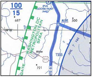
- Additional information and resources regarding SFRA, including procedures for flight in individual areas, may be found on the FAA Safety website at http://www.faasafety.gov
-
Washington, DC, Special Flight Rules Area (SFRA) including the Flight Restricted Zone (FRZ)
A pilot conducting any type of flight operation in the Washington, DC, SFRA/FRZ must comply with the requirements in:
- 14 CFR section 93.339, Washington, DC, Metropolitan Area Special Flight Rules Area including the FRZ.
- 14 CFR section 91.161, Special Awareness Training for the DC SFRA/FRZ, also located on the FAA website at https://www.faasafety.gov/.
- Any 14 CFR section 99.7 special security instructions for the DC SFRA/FRZ published via NOTAM by FAA in the interest of national security.
-
Weather Reconnaissance Area (WRA)
- General. Hurricane Hunters from the United States Air Force Reserve 53rd Weather Reconnaissance Squadron (WRS) and the National Oceanic and Atmospheric Administration (NOAA) Aircraft Operations Center (AOC) operate weather reconnaissance/research aircraft missions, in support of the National Hurricane Operations Plan (NHOP), to gather meteorological data on hurricanes and tropical cyclones. 53rd WRS and NOAA AOC aircraft normally conduct these missions in airspace identified in a published WRA Notice to Airmen (NOTAM).
- WRAs. Airspace with defined dimensions and published by a NOTAM, which is established to support weather reconnaissance/research flights. ATC services are not provided within WRAs. Only participating weather reconnaissance/research aircraft from the 53rd WRS and NOAA AOC are permitted to operate within a WRA. A WRA may only be established in airspace within U. S. Flight Information Regions (FIR) outside of U. S. territorial airspace.
- A published WRA NOTAM describes the airspace dimensions of the WRA and the expected activities within the WRA. WRAs may border adjacent foreign FIRs, but are wholly contained within U.S. FIRs. As ATC services are not provided within a WRA, non-participating aircraft should avoid WRAs, and IFR aircraft should expect to be rerouted to avoid WRAs.
-
Other Non-Charted Airspace Areas
- Stationary or Moving Altitude Reservation (ALTRV). A Stationary or Moving ALTRV is announced via an airspace NOTAM issued by the Central Altitude Reservation Facility (CARF) or ARTCC. These announcements will appear in CARF and/or ARTCC NOTAMS. This airspace ensures non-participating IFR aircraft remain separated from special activity. Non-participating VFR aircraft are permitted to fly through the area but should exercise vigilance.
- ATC ASSIGNED AIRSPACE. Airspace of defined vertical/lateral limits, assigned by ATC, for the purpose of providing air traffic segregation between the specified activities being conducted within the assigned airspace and other IFR air traffic. ATCAA locations and scheduled activation information can be found on the FAA SUA website; a NOTAM will not be issued to announce the activation of this airspace.