You have 0 items in your cart

FAR/AIM
>
Aeronautical Information Manual
>
Chapter 4. Air Traffic Control
>
Section 1. Services Available to Pilots
Section 1. Services Available to Pilots
-
Air Route Traffic Control Centers
Centers are established primarily to provide air traffic service to aircraft operating on IFR flight plans within controlled airspace, and principally during the en route phase of flight.
-
Control Towers
Towers have been established to provide for a safe, orderly and expeditious flow of traffic on and in the vicinity of an airport. When the responsibility has been so delegated, towers also provide for the separation of IFR aircraft in the terminal areas.
REFERENCE-
AIM, Para 5-4-3, Approach Control.
-
Flight Service Stations
Flight Service Stations (FSSs) are air traffic facilities that provide pilot briefings, flight plan processing, en route flight advisories, search and rescue services, and assistance to lost aircraft and aircraft in emergency situations. FSSs also relay ATC clearances, process Notices to Airmen, and broadcast aviation weather and aeronautical information. In Alaska, designated FSSs also take weather observations, and provide Airport Advisory Services (AAS).
-
Recording and Monitoring
- Calls to air traffic control (ATC) facilities (ARTCCs, Towers, FSSs, Central Flow, and Operations Centers) over radio and ATC operational telephone lines (lines used for operational purposes such as controller instructions, briefings, opening and closing flight plans, issuance of IFR clearances and amendments, counter hijacking activities, etc.) may be monitored and recorded for operational uses such as accident investigations, accident prevention, search and rescue purposes, specialist training and evaluation, and technical evaluation and repair of control and communications systems.
- Where the public access telephone is recorded, a beeper tone is not required. In place of the “beep” tone the FCC has substituted a mandatory requirement that persons to be recorded be given notice they are to be recorded and give consent. Notice is given by this entry, consent to record is assumed by the individual placing a call to the operational facility.
-
Communications Release of IFR Aircraft Landing at an Airport Without an Operating Control Tower
Aircraft operating on an IFR flight plan, landing at an airport without an operating control tower will be advised to change to the airport advisory frequency when direct communications with ATC are no longer required. Towers and centers do not have nontower airport traffic and runway in use information. The instrument approach may not be aligned with the runway in use; therefore, if the information has not already been obtained, pilots should make an expeditious change to the airport advisory frequency when authorized.
REFERENCE-
AIM, Para 5-4-4, Advance Information on Instrument Approach.
-
Pilot Visits to Air Traffic Facilities
Pilots are encouraged to participate in local pilot/air traffic control outreach activities. However, due to security and workload concerns, requests for air traffic facility visits may not always be approved. Therefore, visit requests should be submitted through the air traffic facility as early as possible. Pilots should contact the facility and advise them of the number of persons in the group, the time and date of the proposed visit, and the primary interest of the group. The air traffic facility will provide further instructions if a request can be approved.
REFERENCE-
FAA Order 1600.69, FAA Facility Security Management Program.
-
Operation Rain Check
Operation Rain Check is a program designed and managed by local air traffic control facility management. Its purpose is to familiarize pilots and aspiring pilots with the ATC system, its functions, responsibilities and benefits.
REFERENCE-
FAA Order JO 7210.3, Para 4-2-2, Pilot Education.
FAA Order 1600.69, FAA Facility Security Management Program. -
Approach Control Service for VFR Arriving Aircraft
-
Numerous approach control facilities have established programs for arriving VFR aircraft to contact approach control for landing information. This information includes: wind, runway, and altimeter setting at the airport of intended landing. This information may be omitted if contained in the Automatic Terminal Information Service (ATIS) broadcast and the pilot states the appropriate ATIS code.
NOTE-
Pilot use of “have numbers” does not indicate receipt of the ATIS broadcast. In addition, the controller will provide traffic advisories on a workload permitting basis.
- Such information will be furnished upon initial contact with concerned approach control facility. The pilot will be requested to change to the tower frequency at a predetermined time or point, to receive further landing information.
- Where available, use of this procedure will not hinder the operation of VFR flights by requiring excessive spacing between aircraft or devious routing.
-
Compliance with this procedure is not mandatory but pilot participation is encouraged.
REFERENCE-
AIM, Para 4-1-18, Terminal Radar Services for VFR Aircraft.
NOTE-
Approach control services for VFR aircraft are normally dependent on ATC radar. These services are not available during periods of a radar outage.
-
Numerous approach control facilities have established programs for arriving VFR aircraft to contact approach control for landing information. This information includes: wind, runway, and altimeter setting at the airport of intended landing. This information may be omitted if contained in the Automatic Terminal Information Service (ATIS) broadcast and the pilot states the appropriate ATIS code.
-
Traffic Advisory Practices at Airports Without Operating Control Towers
(See TBL 4-1-1.)
-
Airport Operations Without Operating Control Tower
-
There is no substitute for alertness while in the vicinity of an airport. It is essential that pilots be alert and look for other traffic and exchange traffic information when approaching or departing an airport without an operating control tower. This is of particular importance since other aircraft may not have communication capability or, in some cases, pilots may not communicate their presence or intentions when operating into or out of such airports. To achieve the greatest degree of safety, it is essential that:
- All radio-equipped aircraft transmit/receive on a common frequency identified for the purpose of airport advisories; and
- Pilots use the correct airport name, as identified in appropriate aeronautical publications, to reduce the risk of confusion when communicating their position, intentions, and/or exchanging traffic information.
-
An airport may have a full or part‐time tower or FSS located on the airport, a full or part‐time UNICOM station or no aeronautical station at all. There are three ways for pilots to communicate their intention and obtain airport/traffic information when operating at an airport that does not have an operating tower: by communicating with an FSS, a UNICOM operator, or by making a self‐announce broadcast.
NOTE-
FSS airport advisories are available only in Alaska.
- Many airports are now providing completely automated weather, radio check capability and airport advisory information on an automated UNICOM system. These systems offer a variety of features, typically selectable by microphone clicks, on the UNICOM frequency. Availability of the automated UNICOM will be published in the Chart Supplement and approach charts.
-
There is no substitute for alertness while in the vicinity of an airport. It is essential that pilots be alert and look for other traffic and exchange traffic information when approaching or departing an airport without an operating control tower. This is of particular importance since other aircraft may not have communication capability or, in some cases, pilots may not communicate their presence or intentions when operating into or out of such airports. To achieve the greatest degree of safety, it is essential that:
-
Communicating on a Common Frequency
-
The key to communicating at an airport without an operating control tower is selection of the correct common frequency. The acronym CTAF which stands for Common Traffic Advisory Frequency, is synonymous with this program. A CTAF is a frequency designated for the purpose of carrying out airport advisory practices while operating to or from an airport without an operating control tower. The CTAF may be a UNICOM, MULTICOM, FSS, or tower frequency and is identified in appropriate aeronautical publications.
NOTE-
FSS frequencies are available only in Alaska.
TBL 4-1-1
Summary of Recommended Communication ProceduresCommunication/Broadcast Procedures
Facility at Airport
Frequency Use
Outbound
Inbound
Practice Instrument Approach
1.
UNICOM (No Tower or FSS)
Communicate with UNICOM station on published CTAF frequency (122.7; 122.8; 122.725; 122.975; or 123.0). If unable to contact UNICOM station, use self‐announce procedures on CTAF.
Before taxiing and before taxiing on the runway for departure.
10 miles out. Entering downwind, base, and final. Leaving the runway.
2.
No Tower, FSS, or UNICOM
Self‐announce on MULTICOM frequency 122.9.
Before taxiing and before taxiing on the runway for departure.
10 miles out. Entering downwind, base, and final. Leaving the runway.
Departing final approach fix (name) or on final approach segment inbound.
3.
No Tower in operation, FSS open (Alaska only)
Communicate with FSS on CTAF frequency.
Before taxiing and before taxiing on the runway for departure.
10 miles out. Entering downwind, base, and final. Leaving the runway.
Approach completed/terminated.
4.
FSS Closed (No Tower)
Self‐announce on CTAF.
Before taxiing and before taxiing on the runway for departure.
10 miles out. Entering downwind, base, and final. Leaving the runway.
5.
Tower or FSS not in operation
Self‐announce on CTAF.
Before taxiing and before taxiing on the runway for departure.
10 miles out. Entering downwind, base, and final. Leaving the runway.
6.
Designated CTAF Area (Alaska Only)
Self‐announce on CTAF designated on chart or Chart Supplement Alaska.
Before taxiing and before taxiing on the runway for departure until leaving designated area.
When entering designated CTAF area.
- CTAF (Alaska Only). In Alaska, a CTAF may also be designated for the purpose of carrying out advisory practices while operating in designated areas with a high volume of VFR traffic.
- The CTAF frequency for a particular airport or area is contained in the Chart Supplement U.S., Chart Supplement Alaska, Alaska Terminal Publication, Instrument Approach Procedure Charts, and Instrument Departure Procedure (DP) Charts. Also, the CTAF frequency can be obtained by contacting any FSS. Use of the appropriate CTAF, combined with a visual alertness and application of the following recommended good operating practices, will enhance safety of flight into and out of all uncontrolled airports.
-
The key to communicating at an airport without an operating control tower is selection of the correct common frequency. The acronym CTAF which stands for Common Traffic Advisory Frequency, is synonymous with this program. A CTAF is a frequency designated for the purpose of carrying out airport advisory practices while operating to or from an airport without an operating control tower. The CTAF may be a UNICOM, MULTICOM, FSS, or tower frequency and is identified in appropriate aeronautical publications.
-
Recommended Traffic Advisory Practices
- Pilots of inbound traffic should monitor and communicate as appropriate on the designated CTAF from 10 miles to landing. Pilots of departing aircraft should monitor/communicate on the appropriate frequency from start‐up, during taxi, and until 10 miles from the airport unless the CFRs or local procedures require otherwise.
- Pilots of aircraft conducting other than arriving or departing operations at altitudes normally used by arriving and departing aircraft should monitor/communicate on the appropriate frequency while within 10 miles of the airport unless required to do otherwise by the CFRs or local procedures. Such operations include parachute jumping/dropping, en route, practicing maneuvers, etc.
-
In Alaska, pilots of aircraft conducting other than arriving or departing operations in designated CTAF areas should monitor/communicate on the appropriate frequency while within the designated area, unless required to do otherwise by CFRs or local procedures. Such operations include parachute jumping/dropping, en route, practicing maneuvers, etc.
REFERENCE-
AIM, Para 3-5-4, Parachute Jump Aircraft Operations
-
Airport Advisory/Information Services Provided by a FSS
-
There are two advisory type services provided at selected airports.
- Local Airport Advisory (LAA) is available only in Alaska and provided at airports that have a FSS physically located on the airport, which does not have a control tower or where the tower is operated on a part-time basis. The CTAF for LAA airports is disseminated in the appropriate aeronautical publications.
- Remote Airport Information Service (RAIS) is provided in support of special events at nontowered airports by request from the airport authority.
-
In communicating with a CTAF FSS, check the airport's automated weather and establish two-way communications before transmitting outbound/inbound intentions or information. An inbound aircraft should initiate contact approximately 10 miles from the airport, reporting aircraft identification and type, altitude, location relative to the airport, intentions (landing or over flight), possession of the automated weather, and request airport advisory or airport information service. A departing aircraft should initiate contact before taxiing, reporting aircraft identification and type, VFR or IFR, location on the airport, intentions, direction of take-off, possession of the automated weather, and request airport advisory or information service. Also, report intentions before taxiing onto the active runway for departure. If you must change frequencies for other service after initial report to FSS, return to FSS frequency for traffic update.
-
Inbound
EXAMPLE-
Vero Beach radio, Centurion Six Niner Delta Delta is ten miles south, two thousand, landing Vero Beach. I have the automated weather, request airport advisory.
-
Outbound
EXAMPLE-
Vero Beach radio, Centurion Six Niner Delta Delta, ready to taxi to runway 22, VFR, departing to the southwest. I have the automated weather, request airport advisory.
-
Inbound
-
Airport advisory service includes wind direction and velocity, favored or designated runway, altimeter setting, known airborne and ground traffic, NOTAMs, airport taxi routes, airport traffic pattern information, and instrument approach procedures. These elements are varied so as to best serve the current traffic situation. Some airport managers have specified that under certain wind or other conditions designated runways be used. Pilots should advise the FSS of the runway they intend to use.
CAUTION-
All aircraft in the vicinity of an airport may not be in communication with the FSS.
-
There are two advisory type services provided at selected airports.
-
Information Provided by Aeronautical Advisory Stations (UNICOM)
- UNICOM is a nongovernment air/ground radio communication station which may provide airport information at public use airports where there is no tower or FSS.
- On pilot request, UNICOM stations may provide pilots with weather information, wind direction, the recommended runway, or other necessary information. If the UNICOM frequency is designated as the CTAF, it will be identified in appropriate aeronautical publications.
-
Unavailability of Information from FSS or UNICOM
Should LAA by an FSS or Aeronautical Advisory Station UNICOM be unavailable, wind and weather information may be obtainable from nearby controlled airports via Automatic Terminal Information Service (ATIS) or Automated Weather Observing System (AWOS) frequency. -
Self‐Announce Position and/or Intentions
- General.Self‐announce is a procedure whereby pilots broadcast their position or intended flight activity or ground operation on the designated CTAF. This procedure is used primarily at airports which do not have an FSS on the airport. The self‐announce procedure should also be used if a pilot is unable to communicate with the FSS on the designated CTAF. Pilots stating, “Traffic in the area, please advise” is not a recognized Self-Announce Position and/or Intention phrase and should not be used under any condition.
- If an airport has a tower and it is temporarily closed, or operated on a part‐time basis and there is no FSS on the airport or the FSS is closed, use the CTAF to self‐announce your position or intentions.
- Where there is no tower, FSS, or UNICOM station on the airport, use MULTICOM frequency 122.9 for self‐announce procedures. Such airports will be identified in appropriate aeronautical information publications.
- Straight-in Landings. The FAA discourages VFR straight-in approaches to landings due to the increased risk of a mid-air collision. However, if a pilot chooses to execute a straight-in approach for landing without entering the airport traffic pattern, the pilot should self-announce their position on the designated CTAF approximately 8 to 10 miles from the airport and coordinate their straight-in approach and landing with other airport traffic. Pilots executing a straight-in approach (IFR or VFR) do not have priority over other aircraft in the traffic pattern, and must comply with the provisions of 14 CFR 91.113 (g), Right-of-way rules.
-
Traffic Pattern Operations. All traffic within a 10-mile radius of a non-towered airport or a part-time-towered airport when the control tower is not operating, should monitor and communicate on the designated CTAF when entering the traffic pattern. Pilots operating in the traffic pattern or on a straight-in approach must be alert at all times to other aircraft in the pattern, or conducting straight-in approaches, and communicate their position to avoid a possible traffic conflict. In the airport traffic pattern and while on straight-in approaches to a runway, effective communication and a pilot's responsibility to see-and-avoid are essential mitigations to avoid a possible midair collision. In addition, following established traffic pattern procedures eliminates excessive maneuvering at low altitudes, reducing the risk of loss of aircraft control.
REFERENCE-
FAA Advisory Circular (AC) 90-66, Non-Towered Airport Flight Operations.
-
Practice Approaches.Pilots conducting practice instrument approaches should be particularly alert for other aircraft that may be departing in the opposite direction. When conducting any practice approach, regardless of its direction relative to other airport operations, pilots should make announcements on the CTAF as follows:
- Departing the final approach fix, inbound (nonprecision approach) or departing the outer marker or fix used in lieu of the outer marker, inbound (precision approach);
- Established on the final approach segment or immediately upon being released by ATC;
- Upon completion or termination of the approach; and
- Upon executing the missed approach procedure.
- Departing aircraft should always be alert for arrival aircraft coming from the opposite direction.
-
Recommended self-announce broadcasts: It should be noted that aircraft operating to or from another nearby airport may be making self-announce broadcasts on the same UNICOM or MULTICOM frequency. To help identify one airport from another, the airport name should be spoken at the beginning and end of each self-announce transmission. When referring to a specific runway, pilots should use the runway number and not use the phrase “Active Runway.”
-
Inbound
EXAMPLE-
Strawn traffic, Apache Two Two Five Zulu, (position), (altitude), (descending) or entering downwind/base/final (as appropriate) runway one seven full stop, touch-and-go, Strawn.
Strawn traffic Apache Two Two Five Zulu clear of runway one seven Strawn. -
Outbound
EXAMPLE-
Strawn traffic, Queen Air Seven One Five Five Bravo (location on airport) taxiing to runway two six Strawn.
Strawn traffic, Queen Air Seven One Five Five Bravo departing runway two six. Departing the pattern to the (direction), climbing to (altitude) Strawn. -
Practice Instrument Approach
EXAMPLE-
Strawn traffic, Cessna Two One Four Three Quebec (position from airport) inbound descending through (altitude) practice (name of approach) approach runway three five Strawn.
Strawn traffic, Cessna Two One Four Three Quebec practice (type) approach completed or terminated runway three five Strawn.
-
Inbound
-
UNICOM Communications Procedures
-
In communicating with a UNICOM station, the following practices will help reduce frequency congestion, facilitate a better understanding of pilot intentions, help identify the location of aircraft in the traffic pattern, and enhance safety of flight:
- Select the correct UNICOM frequency.
- State the identification of the UNICOM station you are calling in each transmission.
- Speak slowly and distinctly.
- Report approximately 10 miles from the airport, reporting altitude, and state your aircraft type, aircraft identification, location relative to the airport, state whether landing or overflight, and request wind information and runway in use.
- Report on downwind, base, and final approach.
- Report leaving the runway.
-
Recommended UNICOM phraseologies:
-
Inbound
PHRASEOLOGY-
FREDERICK UNICOM CESSNA EIGHT ZERO ONE TANGO FOXTROT 10 MILES SOUTHEAST DESCENDING THROUGH (altitude) LANDING FREDERICK, REQUEST WIND AND RUNWAY INFORMATION FREDERICK.
FREDERICK TRAFFIC CESSNA EIGHT ZERO ONE TANGO FOXTROT ENTERING DOWNWIND/BASE/ FINAL (as appropriate) FOR RUNWAY ONE NINER (full stop/touch-and-go) FREDERICK.
FREDERICK TRAFFIC CESSNA EIGHT ZERO ONE TANGO FOXTROT CLEAR OF RUNWAY ONE NINER FREDERICK. -
Outbound
PHRASEOLOGY-
FREDERICK UNICOM CESSNA EIGHT ZERO ONE TANGO FOXTROT (location on airport) TAXIING TO RUNWAY ONE NINER, REQUEST WIND AND TRAFFIC INFORMATION FREDERICK.
FREDERICK TRAFFIC CESSNA EIGHT ZERO ONE TANGO FOXTROT DEPARTING RUNWAY ONE NINER. “REMAINING IN THE PATTERN” OR “DEPARTING THE PATTERN TO THE (direction) (as appropriate)” FREDERICK.
-
Inbound
-
In communicating with a UNICOM station, the following practices will help reduce frequency congestion, facilitate a better understanding of pilot intentions, help identify the location of aircraft in the traffic pattern, and enhance safety of flight:
-
Airport Operations Without Operating Control Tower
-
IFR Approaches/Ground Vehicle Operations
- IFR Approaches. When operating in accordance with an IFR clearance and ATC approves a change to the advisory frequency, make an expeditious change to the CTAF and employ the recommended traffic advisory procedures.
- Ground Vehicle Operation. Airport ground vehicles equipped with radios should monitor the CTAF frequency when operating on the airport movement area and remain clear of runways/taxiways being used by aircraft. Radio transmissions from ground vehicles should be confined to safety‐related matters.
- Radio Control of Airport Lighting Systems. Whenever possible, the CTAF will be used to control airport lighting systems at airports without operating control towers. This eliminates the need for pilots to change frequencies to turn the lights on and allows a continuous listening watch on a single frequency. The CTAF is published on the instrument approach chart and in other appropriate aeronautical information publications.
-
Designated UNICOM/MULTICOM Frequencies
Frequency use
-
The following listing depicts UNICOM and MULTICOM frequency uses as designated by the Federal Communications Commission (FCC). (See TBL 4-1-2.)
TBL 4-1-2
Unicom/Multicom Frequency UsageUse
Frequency
Airports without an operating control tower.
122.700
122.725
122.800
122.975
123.000
123.050
123.075(MULTICOM FREQUENCY) Activities of a temporary, seasonal, emergency nature or search and rescue, as well as, airports with no tower, FSS, or UNICOM.
122.900
(MULTICOM FREQUENCY) Forestry management and fire suppression, fish and game management and protection, and environmental monitoring and protection.
122.925
Airports with a control tower or FSS on airport.
122.950
NOTE-
- In some areas of the country, frequency interference may be encountered from nearby airports using the same UNICOM frequency. Where there is a problem, UNICOM operators are encouraged to develop a “least interference” frequency assignment plan for airports concerned using the frequencies designated for airports without operating control towers. UNICOM licensees are encouraged to apply for UNICOM 25 kHz spaced channel frequencies. Due to the extremely limited number of frequencies with 50 kHz channel spacing, 25 kHz channel spacing should be implemented. UNICOM licensees may then request FCC to assign frequencies in accordance with the plan, which FCC will review and consider for approval.
- Wind direction and runway information may not be available on UNICOM frequency 122.950.
-
The following listing depicts other frequency uses as designated by the Federal Communications Commission (FCC). (See TBL 4-1-3.)
TBL 4-1-3
Other Frequency Usage Designated by FCCUse
Frequency
Air‐to‐air communication (private fixed wing aircraft).
122.750
Helicopter air-to-air communications; air traffic control operations.
123.025
Aviation instruction, Glider, Hot Air Balloon (not to be used for advisory service).
123.300
123.500Assignment to flight test land and aircraft stations (not for air-to-air communication except for those aircraft operating in an oceanic FIR).
123.4001
123.45021This frequency is available only to itinerant stations that have a requirement to be periodically transferred to various locations.
2Mobile station operations on these frequencies are limited to an area within 320 km (200 mi) of an associated flight test land station.
-
The following listing depicts UNICOM and MULTICOM frequency uses as designated by the Federal Communications Commission (FCC). (See TBL 4-1-2.)
-
Use of UNICOM for ATC Purposes
UNICOM service may be used for ATC purposes, only under the following circumstances:
- Revision to proposed departure time.
- Takeoff, arrival, or flight plan cancellation time.
- ATC clearance, provided arrangements are made between the ATC facility and the UNICOM licensee to handle such messages.
-
Automatic Terminal Information Service (ATIS)
- ATIS is the continuous broadcast of recorded noncontrol information in selected high activity terminal areas. Its purpose is to improve controller effectiveness and to relieve frequency congestion by automating the repetitive transmission of essential but routine information. The information is continuously broadcast over a discrete VHF radio frequency or the voice portion of a local NAVAID. Arrival ATIS transmissions on a discrete VHF radio frequency are engineered according to the individual facility requirements, which would normally be a protected service volume of 20 NM to 60 NM from the ATIS site and a maximum altitude of 25,000 feet AGL. In the case of a departure ATIS, the protected service volume cannot exceed 5 NM and 100 feet AGL. At most locations, ATIS signals may be received on the surface of the airport, but local conditions may limit the maximum ATIS reception distance and/or altitude. Pilots are urged to cooperate in the ATIS program as it relieves frequency congestion on approach control, ground control, and local control frequencies. The Chart Supplement indicates airports for which ATIS is provided.
-
ATIS information includes:
- Airport/facility name
- Phonetic letter code
- Time of the latest weather sequence (UTC)
-
Weather information consisting of:
- Wind direction and velocity
- Visibility
- Obstructions to vision
- Present weather consisting of: sky condition, temperature, dew point, altimeter, a density altitude advisory when appropriate, and other pertinent remarks included in the official weather observation
-
Instrument approach and runway in use.
The ceiling/sky condition, visibility, and obstructions to vision may be omitted from the ATIS broadcast if the ceiling is above 5,000 feet and the visibility is more than 5 miles. The departure runway will only be given if different from the landing runway except at locations having a separate ATIS for departure. The broadcast may include the appropriate frequency and instructions for VFR arrivals to make initial contact with approach control. Pilots of aircraft arriving or departing the terminal area can receive the continuous ATIS broadcast at times when cockpit duties are least pressing and listen to as many repeats as desired. ATIS broadcast must be updated upon the receipt of any official hourly and special weather. A new recording will also be made when there is a change in other pertinent data such as runway change, instrument approach in use, etc.EXAMPLE-
Dulles International information Sierra. One four zero zero zulu. Wind three five zero at eight. Visibility one zero. Ceiling four thousand five hundred broken. Temperature three four. Dew point two eight. Altimeter three zero one zero. ILS runway one right approach in use. Departing runway three zero. Advise on initial contact you have information sierra.
- Pilots should listen to ATIS broadcasts whenever ATIS is in operation.
-
Pilots should notify controllers on initial contact that they have received the ATIS broadcast by repeating the alphabetical code word appended to the broadcast.
EXAMPLE-
“Information Sierra received.”
-
When a pilot acknowledges receipt of the ATIS broadcast, controllers may omit those items contained in the broadcast if they are current. Rapidly changing conditions will be issued by ATC and the ATIS will contain words as follows:
EXAMPLE-
“Latest ceiling/visibility/altimeter/wind/(other conditions) will be issued by approach control/tower.”
NOTE-
The absence of a sky condition or ceiling and/or visibility on ATIS indicates a sky condition or ceiling of 5,000 feet or above and visibility of 5 miles or more. A remark may be made on the broadcast, “the weather is better than 5000 and 5,” or the existing weather may be broadcast.
- Controllers will issue pertinent information to pilots who do not acknowledge receipt of a broadcast or who acknowledge receipt of a broadcast which is not current.
- To serve frequency limited aircraft, FSSs are equipped to transmit on the omnirange frequency at most en route VORs used as ATIS voice outlets. Such communication interrupts the ATIS broadcast. Pilots of aircraft equipped to receive on other FSS frequencies are encouraged to do so in order that these override transmissions may be kept to an absolute minimum.
- While it is a good operating practice for pilots to make use of the ATIS broadcast where it is available, some pilots use the phrase “have numbers” in communications with the control tower. Use of this phrase means that the pilot has received wind, runway, and altimeter information ONLY and the tower does not have to repeat this information. It does not indicate receipt of the ATIS broadcast and should never be used for this purpose.
-
Automatic Flight Information Service (AFIS) - Alaska FSSs Only
-
AFIS is the continuous broadcast of recorded non-control information at airports in Alaska where an FSS provides local airport advisory service. Its purpose is to improve FSS specialist efficiency by reducing frequency congestion on the local airport advisory frequency.
- The AFIS broadcast will automate the repetitive transmission of essential but routine information (for example, weather, favored runway, braking action, airport NOTAMs, etc.). The information is continuously broadcast over a discrete VHF radio frequency (usually the ASOS frequency).
- Use of AFIS is not mandatory, but pilots who choose to utilize two-way radio communications with the FSS are urged to listen to AFIS, as it relieves frequency congestion on the local airport advisory frequency. AFIS broadcasts are updated upon receipt of any official hourly and special weather, and changes in other pertinent data.
-
When a pilot acknowledges receipt of the AFIS broadcast, FSS specialists may omit those items contained in the broadcast if they are current. When rapidly changing conditions exist, the latest ceiling, visibility, altimeter, wind or other conditions may be omitted from the AFIS and will be issued by the FSS specialist on the appropriate radio frequency.
EXAMPLE-
“Kotzebue information ALPHA. One six five five zulu. Wind, two one zero at five; visibility two, fog; ceiling one hundred overcast; temperature minus one two, dew point minus one four; altimeter three one zero five. Altimeter in excess of three one zero zero, high pressure altimeter setting procedures are in effect. Favored runway two six. Weather in Kotzebue surface area is below V-F-R minima - an ATC clearance is required. Contact Kotzebue Radio on 123.6 for traffic advisories and advise intentions. Notice to Airmen, Hotham NDB out of service. Transcribed Weather Broadcast out of service. Advise on initial contact you have ALPHA.”
NOTE-
The absence of a sky condition or ceiling and/or visibility on Alaska FSS AFIS indicates a sky condition or ceiling of 5,000 feet or above and visibility of 5 miles or more. A remark may be made on the broadcast, “the weather is better than 5000 and 5.”
-
Pilots should listen to Alaska FSSs AFIS broadcasts whenever Alaska FSSs AFIS is in operation.
NOTE-
Some Alaska FSSs are open part time and/or seasonally.
-
Pilots should notify controllers on initial contact that they have received the Alaska FSSs AFIS broadcast by repeating the phonetic alphabetic letter appended to the broadcast.
EXAMPLE-
“Information Alpha received.”
- While it is a good operating practice for pilots to make use of the Alaska FSS AFIS broadcast where it is available, some pilots use the phrase “have numbers” in communications with the FSS. Use of this phrase means that the pilot has received wind, runway, and altimeter information ONLY and the Alaska FSS does not have to repeat this information. It does not indicate receipt of the AFIS broadcast and should never be used for this purpose.
-
AFIS is the continuous broadcast of recorded non-control information at airports in Alaska where an FSS provides local airport advisory service. Its purpose is to improve FSS specialist efficiency by reducing frequency congestion on the local airport advisory frequency.
-
Radar Traffic Information Service
This is a service provided by radar ATC facilities. Pilots receiving this service are advised of any radar target observed on the radar display which may be in such proximity to the position of their aircraft or its intended route of flight that it warrants their attention. This service is not intended to relieve the pilot of the responsibility for continual vigilance to see and avoid other aircraft.
-
Purpose of the Service
- The issuance of traffic information as observed on a radar display is based on the principle of assisting and advising a pilot that a particular radar target's position and track indicates it may intersect or pass in such proximity to that pilot's intended flight path that it warrants attention. This is to alert the pilot to the traffic, to be on the lookout for it, and thereby be in a better position to take appropriate action should the need arise.
- Pilots are reminded that the surveillance radar used by ATC does not provide altitude information unless the aircraft is equipped with Mode C and the radar facility is capable of displaying altitude information.
-
Provisions of the Service
-
Many factors, such as limitations of the radar, volume of traffic, controller workload and communications frequency congestion, could prevent the controller from providing this service. Controllers possess complete discretion for determining whether they are able to provide or continue to provide this service in a specific case. The controller's reason against providing or continuing to provide the service in a particular case is not subject to question nor need it be communicated to the pilot. In other words, the provision of this service is entirely dependent upon whether controllers believe they are in a position to provide it. Traffic information is routinely provided to all aircraft operating on IFR flight plans except when the pilot declines the service, or the pilot is operating within Class A airspace. Traffic information may be provided to flights not operating on IFR flight plans when requested by pilots of such flights.
NOTE-
Radar ATC facilities normally display and monitor both primary and secondary radar as well as ADS-B, except that secondary radar or ADS-B may be used as the sole display source in Class A airspace, and under some circumstances outside of Class A airspace (beyond primary coverage and in en route areas where only secondary and/or ADS-B is available). Secondary radar and/or ADS-B may also be used outside Class A airspace as the sole display source when the primary radar is temporarily unusable or out of service. Pilots in contact with the affected ATC facility are normally advised when a temporary outage occurs; i.e., “primary radar out of service; traffic advisories available on transponder or ADS-B aircraft only.” This means simply that only aircraft that have transponders and ADS-B installed and in use will be depicted on ATC displays when the primary and/or secondary radar is temporarily out of service.
-
When receiving VFR radar advisory service, pilots should monitor the assigned frequency at all times. This is to preclude controllers' concern for radio failure or emergency assistance to aircraft under the controller's jurisdiction. VFR radar advisory service does not include vectors away from conflicting traffic unless requested by the pilot. When advisory service is no longer desired, advise the controller before changing frequencies and then change your transponder code to 1200, if applicable. Pilots should also inform the controller when changing VFR cruising altitude. Except in programs where radar service is automatically terminated, the controller will advise the aircraft when radar is terminated.
NOTE-
Participation by VFR pilots in formal programs implemented at certain terminal locations constitutes pilot request. This also applies to participating pilots at those locations where arriving VFR flights are encouraged to make their first contact with the tower on the approach control frequency.
-
Many factors, such as limitations of the radar, volume of traffic, controller workload and communications frequency congestion, could prevent the controller from providing this service. Controllers possess complete discretion for determining whether they are able to provide or continue to provide this service in a specific case. The controller's reason against providing or continuing to provide the service in a particular case is not subject to question nor need it be communicated to the pilot. In other words, the provision of this service is entirely dependent upon whether controllers believe they are in a position to provide it. Traffic information is routinely provided to all aircraft operating on IFR flight plans except when the pilot declines the service, or the pilot is operating within Class A airspace. Traffic information may be provided to flights not operating on IFR flight plans when requested by pilots of such flights.
-
Issuance of Traffic Information. Traffic information will include the following concerning a target which may constitute traffic for an aircraft that is:
-
Radar identified
- Azimuth from the aircraft in terms of the 12 hour clock, or
- When rapidly maneuvering civil test or military aircraft prevent accurate issuance of traffic as in (a) above, specify the direction from an aircraft's position in terms of the eight cardinal compass points (N, NE, E, SE, S, SW, W, NW). This method must be terminated at the pilot's request.
- Distance from the aircraft in nautical miles;
- Direction in which the target is proceeding; and
-
Type of aircraft and altitude if known.
EXAMPLE-
Traffic 10 o'clock, 3 miles, west‐bound (type aircraft and altitude, if known, of the observed traffic). The altitude may be known, by means of Mode C, but not verified with the pilot for accuracy. (To be valid for separation purposes by ATC, the accuracy of Mode C readouts must be verified. This is usually accomplished upon initial entry into the radar system by a comparison of the readout to pilot stated altitude, or the field elevation in the case of continuous readout being received from an aircraft on the airport.) When necessary to issue traffic advisories containing unverified altitude information, the controller will issue the indicated altitude of the aircraft. The pilot may upon receipt of traffic information, request a vector (heading) to avoid such traffic. The vector will be provided to the extent possible as determined by the controller provided the aircraft to be vectored is within the airspace under the jurisdiction of the controller.
-
Not radar identified
- Distance and direction with respect to a fix;
- Direction in which the target is proceeding; and
-
Type of aircraft and altitude if known.
EXAMPLE-
Traffic 8 miles south of the airport northeast-bound, (type aircraft and altitude if known).
-
Radar identified
-
The examples depicted in the following figures point out the possible error in the position of this traffic when it is necessary for a pilot to apply drift correction to maintain this track. This error could also occur in the event a change in course is made at the time radar traffic information is issued.
FIG 4-1-1
Induced Error in Position of Traffic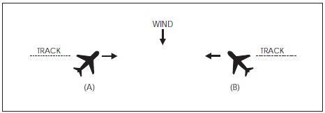
EXAMPLE-
In FIG 4-1-1 traffic information would be issued to the pilot of aircraft “A” as 12 o'clock. The actual position of the traffic as seen by the pilot of aircraft “A” would be 2 o'clock. Traffic information issued to aircraft “B” would also be given as 12 o'clock, but in this case, the pilot of “B” would see the traffic at 10 o'clock.
FIG 4-1-2
Induced Error in Position of Traffic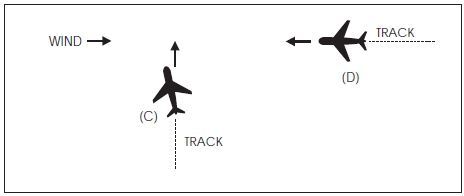
EXAMPLE-
In FIG 4-1-2 traffic information would be issued to the pilot of aircraft “C” as 2 o'clock. The actual position of the traffic as seen by the pilot of aircraft “C” would be 3 o'clock. Traffic information issued to aircraft “D” would be at an 11 o'clock position. Since it is not necessary for the pilot of aircraft “D” to apply wind correction (crab) to remain on track, the actual position of the traffic issued would be correct. Since the radar controller can only observe aircraft track (course) on the radar display, traffic advisories are issued accordingly, and pilots should give due consideration to this fact when looking for reported traffic.
-
Purpose of the Service
-
Safety Alert
A safety alert will be issued to pilots of aircraft being controlled by ATC if the controller is aware the aircraft is at an altitude which, in the controller's judgment, places the aircraft in unsafe proximity to terrain, obstructions or other aircraft. The provision of this service is contingent upon the capability of the controller to have an awareness of a situation involving unsafe proximity to terrain, obstructions and uncontrolled aircraft. The issuance of a safety alert cannot be mandated, but it can be expected on a reasonable, though intermittent basis. Once the alert is issued, it is solely the pilot's prerogative to determine what course of action, if any, to take. This procedure is intended for use in time critical situations where aircraft safety is in question. Noncritical situations should be handled via the normal traffic alert procedures.
-
Terrain or Obstruction Alert
-
Controllers will immediately issue an alert to the pilot of an aircraft under their control when they recognize that the aircraft is at an altitude which, in their judgment, may be in an unsafe proximity to terrain/obstructions. The primary method of detecting unsafe proximity is through Mode C automatic altitude reports.
EXAMPLE-
Low altitude alert Cessna Three Four Juliett, check your altitude immediately. And if the aircraft is not yet on final approach, the MVA (MEA/MIA/MOCA) in your area is six thousand.
- Most En Route and Terminal radar facilities have an automated function which, if operating, alerts controllers when a tracked Mode C equipped aircraft under their control is below or is predicted to be below a predetermined minimum safe altitude. This function, called Minimum Safe Altitude Warning (MSAW), is designed solely as a controller aid in detecting potentially unsafe aircraft proximity to terrain/obstructions. The radar facility will, when MSAW is operating, provide MSAW monitoring for all aircraft with an operating Mode C altitude encoding transponder that are tracked by the system and are:
- Due to the lack of terrain and obstacle clearance data, accurate automation databases may not be available for providing MSAW information to aircraft overflying Mexico and Canada. Air traffic facilities along the United States/Mexico/Canada borders may have MSAW computer processing inhibited where accurate terrain data is not available.
-
Controllers will immediately issue an alert to the pilot of an aircraft under their control when they recognize that the aircraft is at an altitude which, in their judgment, may be in an unsafe proximity to terrain/obstructions. The primary method of detecting unsafe proximity is through Mode C automatic altitude reports.
-
Aircraft Conflict Alert.
-
Controllers will immediately issue an alert to the pilot of an aircraft under their control if they are aware of another aircraft which is not under their control, at an altitude which, in the controller's judgment, places both aircraft in unsafe proximity to each other. With the alert, when feasible, the controller will offer the pilot the position of the traffic if time permits and an alternate course(s) of action. Any alternate course(s) of action the controller may recommend to the pilot will be predicated only on other traffic being worked by the controller.
EXAMPLE-
American Three, traffic alert, (position of traffic, if time permits), advise you turn right/left heading (degrees) and/or climb/descend to (altitude) immediately.
-
Controllers will immediately issue an alert to the pilot of an aircraft under their control if they are aware of another aircraft which is not under their control, at an altitude which, in the controller's judgment, places both aircraft in unsafe proximity to each other. With the alert, when feasible, the controller will offer the pilot the position of the traffic if time permits and an alternate course(s) of action. Any alternate course(s) of action the controller may recommend to the pilot will be predicated only on other traffic being worked by the controller.
-
Terrain or Obstruction Alert
-
Radar Assistance to VFR Aircraft
- Radar equipped FAA ATC facilities provide radar assistance and navigation service (vectors) to VFR aircraft provided the aircraft can communicate with the facility, are within radar coverage, and can be radar identified.
- Pilots should clearly understand that authorization to proceed in accordance with such radar navigational assistance does not constitute authorization for the pilot to violate CFRs. In effect, assistance provided is on the basis that navigational guidance information issued is advisory in nature and the job of flying the aircraft safely, remains with the pilot.
- In many cases, controllers will be unable to determine if flight into instrument conditions will result from their instructions. To avoid possible hazards resulting from being vectored into IFR conditions, pilots should keep controllers advised of the weather conditions in which they are operating and along the course ahead.
-
Radar navigation assistance (vectors) may be initiated by the controller when one of the following conditions exist:
- The controller suggests the vector and the pilot concurs.
- A special program has been established and vectoring service has been advertised.
- In the controller's judgment the vector is necessary for air safety.
- Radar navigation assistance (vectors) and other radar derived information may be provided in response to pilot requests. Many factors, such as limitations of radar, volume of traffic, communications frequency, congestion, and controller workload could prevent the controller from providing it. Controllers have complete discretion for determining if they are able to provide the service in a particular case. Their decision not to provide the service in a particular case is not subject to question.
-
Terminal Radar Services for VFR Aircraft
-
Basic Radar Service:
-
In addition to the use of radar for the control of IFR aircraft, all commissioned radar facilities provide the following basic radar services for VFR aircraft:
- Safety alerts.
- Traffic advisories.
- Limited radar vectoring (on a workload permitting basis).
-
Sequencing at locations where procedures have been established for this purpose and/or when covered by a Letter of Agreement.
NOTE-
When the stage services were developed, two basic radar services (traffic advisories and limited vectoring) were identified as “Stage I.” This definition became unnecessary and the term “Stage I” was eliminated from use. The term “Stage II” has been eliminated in conjunction with the airspace reclassification, and sequencing services to locations with local procedures and/or letters of agreement to provide this service have been included in basic services to VFR aircraft. These basic services will still be provided by all terminal radar facilities whether they include Class B, Class C, Class D or Class E airspace. “Stage III” services have been replaced with “Class B” and “TRSA” service where applicable.
- Vectoring service may be provided when requested by the pilot or with pilot concurrence when suggested by ATC.
- Pilots of arriving aircraft should contact approach control on the publicized frequency and give their position, altitude, aircraft call sign, type aircraft, radar beacon code (if transponder equipped), destination, and request traffic information.
- Approach control will issue wind and runway, except when the pilot states “have numbers” or this information is contained in the ATIS broadcast and the pilot states that the current ATIS information has been received. Traffic information is provided on a workload permitting basis. Approach control will specify the time or place at which the pilot is to contact the tower on local control frequency for further landing information. Radar service is automatically terminated and the aircraft need not be advised of termination when an arriving VFR aircraft receiving radar services to a tower-controlled airport where basic radar service is provided has landed, or to all other airports, is instructed to change to tower or advisory frequency. (See FAA Order JO 7110.65, Air Traffic Control, paragraph 5-1-9, Radar Service Termination.)
-
Sequencing for VFR aircraft is available at certain terminal locations (see locations listed in the Chart Supplement). The purpose of the service is to adjust the flow of arriving VFR and IFR aircraft into the traffic pattern in a safe and orderly manner and to provide radar traffic information to departing VFR aircraft. Pilot participation is urged but is not mandatory. Traffic information is provided on a workload permitting basis. Standard radar separation between VFR or between VFR and IFR aircraft is not provided.
- Pilots of arriving VFR aircraft should initiate radio contact on the publicized frequency with approach control when approximately 25 miles from the airport at which sequencing services are being provided. On initial contact by VFR aircraft, approach control will assume that sequencing service is requested. After radar contact is established, the pilot may use pilot navigation to enter the traffic pattern or, depending on traffic conditions, approach control may provide the pilot with routings or vectors necessary for proper sequencing with other participating VFR and IFR traffic en route to the airport. When a flight is positioned behind a preceding aircraft and the pilot reports having that aircraft in sight, the pilot will be instructed to follow the preceding aircraft. THE ATC INSTRUCTION TO FOLLOW THE PRECEDING AIRCRAFT DOES NOT AUTHORIZE THE PILOT TOCOMPLY WITH ANY ATC CLEARANCE OR INSTRUCTION ISSUED TO THE PRECEDING AIRCRAFT. If other “nonparticipating” or “local” aircraft are in the traffic pattern, the tower will issue a landing sequence. If an arriving aircraft does not want radar service, the pilot should state “NEGATIVE RADAR SERVICE” or make a similar comment, on initial contact with approach control.
-
Pilots of departing VFR aircraft are encouraged to request radar traffic information by notifying ground control, or where applicable, clearance delivery, on initial contact with their request and proposed direction of flight.
EXAMPLE-
Xray ground control, November One Eight Six, Cessna One Seventy Two, ready to taxi, VFR southbound at 2,500, have information bravo and request radar traffic information.
NOTE-
Following takeoff, the tower will advise when to contact departure control.
- Pilots of aircraft transiting the area and in radar contact/communication with approach control will receive traffic information on a controller workload permitting basis. Pilots of such aircraft should give their position, altitude, aircraft call sign, aircraft type, radar beacon code (if transponder equipped), destination, and/or route of flight.
-
In addition to the use of radar for the control of IFR aircraft, all commissioned radar facilities provide the following basic radar services for VFR aircraft:
-
TRSA Service (Radar Sequencing and Separation Service for VFR Aircraft in a TRSA).
- This service has been implemented at certain terminal locations. The service is advertised in the Chart Supplement. The purpose of this service is to provide separation between all participating VFR aircraft and all IFR aircraft operating within the airspace defined as the Terminal Radar Service Area (TRSA). Pilot participation is urged but is not mandatory.
- If any aircraft does not want the service, the pilot should state “NEGATIVE TRSA SERVICE” or make a similar comment, on initial contact with approach control or ground control, as appropriate.
- TRSAs are depicted on sectional aeronautical charts and listed in the Chart Supplement.
- While operating within a TRSA, pilots are provided TRSA service and separation as prescribed in this paragraph. In the event of a radar outage, separation and sequencing of VFR aircraft will be suspended as this service is dependent on radar. The pilot will be advised that the service is not available and issued wind, runway information, and the time or place to contact the tower. Traffic information will be provided on a workload permitting basis.
-
Visual separation is used when prevailing conditions permit and it will be applied as follows:
- When a VFR flight is positioned behind a preceding aircraft and the pilot reports having that aircraft in sight, the pilot will be instructed by ATC to follow the preceding aircraft. Radar service will be continued to the runway. THE ATC INSTRUCTION TO FOLLOW THE PRECEDING AIRCRAFT DOES NOT AUTHORIZE THE PILOT TO COMPLY WITH ANY ATC CLEARANCE OR INSTRUCTION ISSUED TO THE PRECEDING AIRCRAFT.
- If other “nonparticipating” or “local” aircraft are in the traffic pattern, the tower will issue a landing sequence.
- Departing VFR aircraft may be asked if they can visually follow a preceding departure out of the TRSA. The pilot will be instructed to follow the other aircraft provided that the pilot can maintain visual contact with that aircraft.
-
Participating VFR aircraft will be separated from IFR and other participating VFR aircraft by one of the following:
- 500 feet vertical separation.
- Visual separation.
- Target resolution (a process to ensure that correlated radar targets do not touch).
-
Participating pilots operating VFR in a TRSA:
- Must maintain an altitude when assigned by ATC unless the altitude assignment is to maintain at or below a specified altitude. ATC may assign altitudes for separation that do not conform to 14 CFR section 91.159. When the altitude assignment is no longer needed for separation or when leaving the TRSA, the instruction will be broadcast, “RESUME APPROPRIATE VFR ALTITUDES.” Pilots must then return to an altitude that conforms to 14 CFR section 91.159 as soon as practicable.
- When not assigned an altitude, the pilot should coordinate with ATC prior to any altitude change.
- Within the TRSA, traffic information on observed but unidentified targets will, to the extent possible, be provided to all IFR and participating VFR aircraft. The pilot will be vectored upon request to avoid the observed traffic, provided the aircraft to be vectored is within the airspace under the jurisdiction of the controller.
- Departing aircraft should inform ATC of their intended destination and/or route of flight and proposed cruising altitude.
- ATC will normally advise participating VFR aircraft when leaving the geographical limits of the TRSA. Radar service is not automatically terminated with this advisory unless specifically stated by the controller.
- Class C Service. This service provides, in addition to basic radar service, approved separation between IFR and VFR aircraft, and sequencing of VFR arrivals to the primary airport.
- Class B Service. This service provides, in addition to basic radar service, approved separation of aircraft based on IFR, VFR, and/or weight, and sequencing of VFR arrivals to the primary airport(s).
- PILOT RESPONSIBILITY. THESE SERVICES ARE NOT TO BE INTERPRETED AS RELIEVING PILOTS OF THEIR RESPONSIBILITIES TO SEE AND AVOID OTHER TRAFFIC OPERATING IN BASIC VFR WEATHER CONDITIONS, TO ADJUST THEIR OPERATIONS AND FLIGHT PATH AS NECESSARY TO PRECLUDE SERIOUS WAKE ENCOUNTERS, TO MAINTAIN APPROPRIATE TERRAIN AND OBSTRUCTION CLEARANCE, OR TO REMAIN IN WEATHER CONDITIONS EQUAL TO OR BETTER THAN THE MINIMUMS REQUIRED BY 14 CFR SECTION 91.155. WHENEVER COMPLIANCE WITH AN ASSIGNED ROUTE, HEADING AND/OR ALTITUDE IS LIKELY TO COMPROMISE PILOT RESPONSIBILITY RESPECTING TERRAIN AND OBSTRUCTION CLEARANCE, VORTEX EXPOSURE, AND WEATHER MINIMUMS, APPROACH CONTROL SHOULD BE SO ADVISED AND A REVISED CLEARANCE OR INSTRUCTION OBTAINED.
-
ATC services for VFR aircraft participating in terminal radar services are dependent on ATC radar. Services for VFR aircraft are not available during periods of a radar outage. The pilot will be advised when VFR services are limited or not available.
NOTE-
Class B and Class C airspace are areas of regulated airspace. The absence of ATC radar does not negate the requirement of an ATC clearance to enter Class B airspace or two way radio contact with ATC to enter Class C airspace.
-
Basic Radar Service:
-
Tower En Route Control (TEC)
- TEC is an ATC program to provide a service to aircraft proceeding to and from metropolitan areas. It links designated Approach Control Areas by a network of identified routes made up of the existing airway structure of the National Airspace System. The FAA initiated an expanded TEC program to include as many facilities as possible. The program's intent is to provide an overflow resource in the low altitude system which would enhance ATC services. A few facilities have historically allowed turbojets to proceed between certain city pairs, such as Milwaukee and Chicago, via tower en route and these locations may continue this service. However, the expanded TEC program will be applied, generally, for nonturbojet aircraft operating at and below 10,000 feet. The program is entirely within the approach control airspace of multiple terminal facilities. Essentially, it is for relatively short flights. Participating pilots are encouraged to use TEC for flights of two hours duration or less. If longer flights are planned, extensive coordination may be required within the multiple complex which could result in unanticipated delays.
- Pilots requesting TEC are subject to the same delay factor at the destination airport as other aircraft in the ATC system. In addition, departure and en route delays may occur depending upon individual facility workload. When a major metropolitan airport is incurring significant delays, pilots in the TEC program may want to consider an alternative airport experiencing no delay.
- There are no unique requirements upon pilots to use the TEC program. Normal flight plan filing procedures will ensure proper flight plan processing. Pilots should include the acronym “TEC” in the remarks section of the flight plan when requesting tower en route control.
- All approach controls in the system may not operate up to the maximum TEC altitude of 10,000 feet. IFR flight may be planned to any satellite airport in proximity to the major primary airport via the same routing.
-
Transponder and ADS-B Out Operation
-
General
- Pilots should be aware that proper application of transponder and ADS-B operating procedures will provide both VFR and IFR aircraft with a higher degree of safety while operating on the ground and airborne. Transponder/ADS-B panel designs differ; therefore, a pilot should be thoroughly familiar with the operation of their particular equipment to maximize its full potential. ADS-B Out, and transponders with altitude reporting mode turned ON (Mode C or S), substantially increase the capability of surveillance systems to see an aircraft. This provides air traffic controllers, as well as pilots of suitably equipped aircraft (TCAS and ADS-B In), increased situational awareness and the ability to identify potential traffic conflicts. Even VFR pilots who are not in contact with ATC will be afforded greater protection from IFR aircraft and VFR aircraft that are receiving traffic advisories. Nevertheless, pilots should never relax their visual scanning for other aircraft, and should include the ADS-B In display (if equipped) in their normal traffic scan.
- Air Traffic Control Radar Beacon System (ATCRBS) is similar to and compatible with military coded radar beacon equipment. Civil Mode A is identical to military Mode 3.
-
Transponder and ADS-B operations on the ground. Civil and military aircraft should operate with the transponder in the altitude reporting mode (consult the aircraft's flight manual to determine the specific transponder position to enable altitude reporting) and ADS-B Out transmissions enabled at all airports, any time the aircraft is positioned on any portion of the airport movement area. This includes all defined taxiways and runways. Pilots must pay particular attention to ATIS and airport diagram notations, General Notes (included on airport charts), and comply with directions pertaining to transponder and ADS-B usage. Generally, these directions are:
- Departures. Select the transponder mode which allows altitude reporting and enable ADS-B during pushback or taxi-out from parking spot. Select TA or TA/RA (if equipped with TCAS) when taking the active runway.
- Arrivals. If TCAS equipped, deselect TA or TA/RA upon leaving the active runway, but continue transponder and ADS-B transmissions in the altitude reporting mode. Select STBY or OFF for transponder and ADS-B upon arriving at the aircraft's parking spot or gate.
-
Transponder and ADS-B Operations While Airborne.
- Unless otherwise requested by ATC, aircraft equipped with an ATC transponder maintained in accordance with 14 CFR section 91.413 MUST operate with this equipment on the appropriate Mode 3/A code, or other code as assigned by ATC, and with altitude reporting enabled whenever in controlled airspace. If practicable, aircraft SHOULD operate with the transponder enabled in uncontrolled airspace.
- Aircraft equipped with ADS-B Out MUST operate with this equipment in the transmit mode at all times, unless otherwise requested by ATC.
-
Transponder and ADS-B Operation Under Visual Flight Rules (VFR).
- Unless otherwise instructed by an ATC facility, adjust transponder/ADS-B to reply on Mode 3/A Code 1200 regardless of altitude.
- When required to operate their transponder/ADS-B, pilots must always operate that equipment with altitude reporting enabled unless otherwise instructed by ATC or unless the installed equipment has not been tested and calibrated as required by 14 CFR section 91.217. If deactivation is required, turn off altitude reporting.
-
When participating in a VFR standard formation flight that is not receiving ATC services, only the lead aircraft should operate its transponder and ADS-B Out and squawk code 1203. Once established in formation, all other aircraft should squawk standby and disable ADS-B transmissions.
NOTE-
- If the formation flight is receiving ATC services, pilots can expect ATC to direct all non-lead aircraft to STOP Squawk, and should not do so until instructed.
- Firefighting aircraft not in contact with ATC may squawk 1255 in lieu of 1200 while en route to, from, or within the designated firefighting area(s).
- VFR aircraft flying authorized SAR missions for the USAF or USCG may be advised to squawk 1277 in lieu of 1200 while en route to, from, or within the designated search area.
- VFR gliders should squawk 1202 in lieu of 1200.
REFERENCE-
FAA Order JO 7110.66, National Beacon Code Allocation Plan (NBCAP).
- A pilot on an IFR flight who elects to cancel the IFR flight plan prior to reaching their destination, should adjust the transponder/ADS-B according to VFR operations.
- If entering a U.S. OFFSHORE AIRSPACE AREA from outside the U.S., the pilot should advise on first radio contact with a U.S. radar ATC facility that such equipment is available by adding “transponder” or “ADS-B” (if equipped) to the aircraft identification.
-
It should be noted by all users of ATC transponders and ADS-B Out systems that the surveillance coverage they can expect is limited to “line of sight” with ground radar and ADS-B radio sites. Low altitude or aircraft antenna shielding by the aircraft itself may result in reduced range or loss of aircraft contact. Though ADS-B often provides superior reception at low altitudes, poor coverage from any surveillance system can be improved by climbing to a higher altitude.
NOTE-
Pilots should refer to AIM, paragraph 4-5-7, Automatic Dependent Surveillance - Broadcast (ADS-B) Services, for a complete description of operating limitations and procedures.
-
Transponder/ADS-B Code Designation
-
For ATC to utilize one of the 4096 discrete codes, a four-digit code designation will be used; for example, code 2102 will be expressed as “TWO ONE ZERO TWO.”
NOTE-
Circumstances may occasionally require ATC to assign a non-discrete code; i.e., a code ending in “00.”
REFERENCE-
FAA Order JO 7110.66, National Beacon Code Allocation Plan (NBCAP).
-
For ATC to utilize one of the 4096 discrete codes, a four-digit code designation will be used; for example, code 2102 will be expressed as “TWO ONE ZERO TWO.”
-
Automatic Altitude Reporting
- Most transponders (Modes C and S) and all ADS-B Out systems are capable of automatic altitude reporting. This system converts aircraft altitude in 100-foot increments to coded digital information that is transmitted to the appropriate surveillance facility as well as to ADS-B In and TCAS systems.
-
Adjust the transponder/ADS-B to reply on the Mode 3/A code specified by ATC and with altitude reporting enabled, unless otherwise directed by ATC or unless the altitude reporting equipment has not been tested and calibrated as required by 14 CFR section 91.217. If deactivation is required by ATC, turn off the altitude reporting feature of your transponder/ADS-B. An instruction by ATC to “STOP ALTITUDE SQUAWK, ALTITUDE DIFFERS BY (number of feet) FEET,” may be an indication that the transmitted altitude information is incorrect, or that the aircraft's altimeter setting is incorrect. While an incorrect altimeter setting has no effect on the transmitted altitude information, it will cause the aircraft to fly at a true altitude different from the assigned altitude. When a controller indicates that an altitude readout is invalid, the pilot should verify that the aircraft altimeter is set correctly.
NOTE-
Altitude encoders are preset at standard atmospheric pressure. Local altimeter correction is applied by the surveillance facility before the altitude information is presented to ATC.
- Pilots should report exact altitude or flight level to the nearest hundred foot increment when establishing initial contact with an ATC facility. Exact altitude or flight level reports on initial contact provide ATC with information that is required prior to using automatically reported altitude information for separation purposes. This will significantly reduce altitude verification requests.
-
IDENT Feature
Transponder/ADS-B Out equipment must be operated only as specified by ATC. Activate the “IDENT” feature only when requested by ATC. -
Code Changes
- When making routine code changes, pilots should avoid inadvertent selection of Codes 7500, 7600 or 7700 thereby causing momentary false alarms at automated ground facilities. For example, when switching from Code 2700 to Code 7200, switch first to 2200 then to 7200, NOT to 7700 and then 7200. This procedure applies to nondiscrete Code 7500 and all discrete codes in the 7600 and 7700 series (i.e., 7600-7677, 7700-7777) which will trigger special indicators in automated facilities. Only nondiscrete Code 7500 will be decoded as the hijack code.
- Under no circumstances should a pilot of a civil aircraft operate the transponder on Code 7777. This code is reserved for military interceptor operations.
- Military pilots operating VFR or IFR within restricted/warning areas should adjust their transponders to Code 4000 unless another code has been assigned by ATC.
-
Mode C Transponder and ADS-B Out Requirements
- Specific details concerning requirements to carry and operate Mode C transponders and ADS-B Out, as well as exceptions and ATC authorized deviations from those requirements, are found in 14 CFR sections 91.215, 91.225, and 99.13.
-
In general, the CFRs require aircraft to be equipped with an operable Mode C transponder and ADS-B Out when operating:
- In Class A, Class B, or Class C airspace areas;
- Above the ceiling and within the lateral boundaries of Class B or Class C airspace up to 10,000 feet MSL;
- Class E airspace at and above 10,000 feet MSL within the 48 contiguous states and the District of Columbia, excluding the airspace at and below 2,500 feet AGL;
- Within 30 miles of a Class B airspace primary airport, below 10,000 feet MSL (commonly referred to as the “Mode C Veil”);
-
For ADS-B Out: Class E airspace at and above 3,000 feet MSL over the Gulf of America from the coastline of the United States out to 12 nautical miles.
NOTE-
The airspace described in (e) above is specified in 14 CFR § 91.225 for ADS-B Out requirements. However, 14 CFR § 91.215 does not include this airspace for ATC transponder requirements.
-
Transponder and ADS-B Out requirements do not apply to any aircraft that was not originally certificated with an electrical system, or that has not subsequently been certified with such a system installed, including balloons and gliders. These aircraft may conduct operations without a transponder or ADS-B Out when operating:
- Outside any Class B or Class C airspace area; and
- Below the altitude of the ceiling of a Class B or Class C airspace area designated for an airport, or 10,000 feet MSL, whichever is lower.
-
14 CFR section 99.13 requires all aircraft flying into, within, or across the contiguous U.S. ADIZ be equipped with a Mode C or Mode S transponder. Balloons, gliders and aircraft not equipped with an engine-driven electrical system are excepted from this requirement.
REFERENCE-
AIM, Chapter 5, Section 6, National Security and Interception Procedures.
- Pilots must ensure that their aircraft transponder/ADS-B is operating on an appropriate ATC-assigned VFR/IFR code with altitude reporting enabled when operating in such airspace. If in doubt about the operational status of either feature of your transponder while airborne, contact the nearest ATC facility or FSS and they will advise you what facility you should contact for determining the status of your equipment.
- In-flight requests for “immediate” deviation from the transponder requirements may be approved by controllers only for failed equipment, and only when the flight will continue IFR or when weather conditions prevent VFR descent and continued VFR flight in airspace not affected by the CFRs. All other requests for deviation should be made at least 1 hour before the proposed operation by contacting the nearest Flight Service or Air Traffic facility in person or by telephone. The nearest ARTCC will normally be the controlling agency and is responsible for coordinating requests involving deviations in other ARTCC areas.
- In-flight requests for “immediate” deviation from the ADS-B Out requirements may be approved by ATC only for failed equipment, and may be accommodated based on workload, alternate surveillance availability, or other factors. All other requests for deviation must be made at least 1 hour before the proposed operation, following the procedures contained in Advisory Circular (AC) 90-114, Automatic Dependent Surveillance-Broadcast Operations.
-
Cooperative Surveillance Phraseology. Air traffic controllers, both civil and military, will use the following phraseology when referring to operation of cooperative ATC surveillance equipment. Except as noted, the following ATC instructions do not apply to military transponders operating in other than Mode 3/A/C/S.
- SQUAWK (number).Operate radar beacon transponder/ADS-B on designated code with altitude reporting enabled.
- IDENT.Engage the “IDENT” feature (military I/P) of the transponder/ADS-B.
- SQUAWK (number) AND IDENT.Operate transponder/ADS-B on specified code with altitude reporting enabled, and engage the “IDENT” (military I/P) feature.
- SQUAWK STANDBY.Switch transponder/ADS-B to standby position.
- SQUAWK NORMAL. Resume normal transponder/ADS-B operation on previously assigned code. (Used after “SQUAWK STANDBY,” or by military after specific transponder tests).
- SQUAWK ALTITUDE.Activate Mode C with automatic altitude reporting.
- STOP ALTITUDE SQUAWK.Turn off automatic altitude reporting.
- STOP SQUAWK (Mode in use).Stop transponder and ADS-B Out transmissions, or switch off only specified mode of the aircraft transponder (military).
- SQUAWK MAYDAY.Operate transponder/ADS-B in the emergency position (Mode A Code 7700 for civil transponder. Mode 3 Code 7700 and emergency feature for military transponder.)
- SQUAWK VFR.Operate radar beacon transponder/ADS-B on Code 1200 in the Mode A/3, or other appropriate VFR code, with altitude reporting enabled.
-
General
-
Airport Reservation Operations and Special Traffic Management Programs
This section describes procedures for obtaining required airport reservations at airports designated by the FAA and for airports operating under Special Traffic Management Programs.
-
Slot Controlled Airports.
- The FAA may adopt rules to require advance reservations for unscheduled operations at certain airports. In addition to the information in the rules adopted by the FAA, a listing of the airports and relevant information will be maintained on the FAA website www.fly.faa.gov/ecvrs.
- The FAA has established an Airport Reservation Office (ARO) to receive and process reservations for unscheduled flights at the slot controlled airports. The ARO uses the Enhanced Computer Voice Reservation System (e-CVRS) to allocate reservations. Reservations will be available beginning 72 hours in advance of the operation at the slot controlled airport. Standby lists are not maintained. Flights with declared emergencies do not require reservations. Refer to the website for the current listing of slot controlled airports, limitations, and reservation procedures.
- For more detailed information on operations and reservation procedures at a Slot Controlled Airport, please see 14 CFR part 93, Subpart K - High Density Traffic Airports.
-
Special Traffic Management Programs (STMP).
- Special programs may be established when a location requires special traffic handling to accommodate above normal traffic demand (for example, EAA AirVenture Oshkosh, SUN 'n FUN Aerospace Expo) or reduced airport capacity (for example, airport runway/taxiway closures for airport construction). The special programs may remain in effect until the problem has been resolved or until local traffic management procedures can handle the volume and a need for special handling no longer exists.
- If an STMP is used to accommodate a special event, a domestic notice will be issued relaying the website address: www.fly.faa.gov/estmp. Domestic notice information includes: what airports are included in the STMP, the dates and times reservations are required, the time limits for reservation requests, the point of contact for reservations, and any other instructions.
-
Making Reservations. Detailed information and User Instruction Guides for using the Web reservation systems are available on the websites for the slot controlled airports (e-CVRS), www.fly.faa.gov/ecvrs; and STMPs (e-STMP), www.fly.faa.gov/estmp.
NOTE-
Users may contact the ARO at (540) 422-4246 if they have a problem with their reservation.
-
Slot Controlled Airports.
-
Requests for Waivers and Authorizations from Title 14, Code of Federal Regulations (14 CFR)
- Requests for a Certificate of Waiver or Authorization (FAA Form 7711-2), or requests for renewal of a waiver or authorization, may be accepted by any FAA facility and will be forwarded, if necessary, to the appropriate office having waiver authority.
- The grant of a Certificate of Waiver or Authorization from 14 CFR constitutes relief from specific regulations, to the degree and for the period of time specified in the certificate, and does not waive any state law or local ordinance. Should the proposed operations conflict with any state law or local ordinance, or require permission of local authorities or property owners, it is the applicant's responsibility to resolve the matter. The holder of a waiver is responsible for compliance with the terms of the waiver and its provisions.
- A waiver may be canceled at any time by the Administrator, the person authorized to grant the waiver, or the representative designated to monitor a specific operation. In such case either written notice of cancellation, or written confirmation of a verbal cancellation will be provided to the holder.
-
Weather Systems Processor
The Weather Systems Processor (WSP) was developed for use in the National Airspace System to provide weather processor enhancements to selected Airport Surveillance Radar (ASR)-9 facilities. The WSP provides Air Traffic with warnings of hazardous wind shear and microbursts. The WSP also provides users with terminal area 6-level weather, storm cell locations and movement, as well as the location and predicted future position and intensity of wind shifts that may affect airport operations.